Striking map of Myanmar (Burma) Thailand, Cambodia, Vietnam and Malaysia, with decorative title cartouche engraved by Giuseppe Pitteri. The map was issued in Zatta’s Atlante Novissimo, a monumental 4 volume work and one of the last great decorative atlases. Features a striking cartouche.

Regni D’Aracan del Pegu di Siam de Camboge e di Laos
- Year: 1779
- Dimension: 410 x 325 mm
- Place of publication: Venice
€ 400,00
Related products
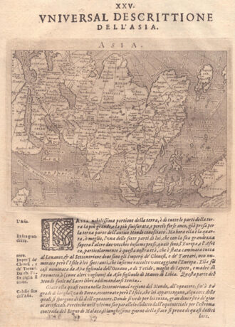
-
![]()
Fascinating map of Asia based on Ortelius’with the exception of the addition of a strait dividing the southern portion of the Malay Peninsula. Interesting depiction of Japan, no sign of the Korean Peninsula. Includes region south of Nova Guinea that is marked as Terrae Incognita Australis, separated from Nova Guinea by a narrow channel. Engraved by Girolamo Porro for “Geografia di Claudio Tolomeo” by Giovanni Antonio Magini published in Padua, 1621.
- Year: 1621
- Dimension: 14 x 18 cm
- Place of publication: Padova
-
![]()
Charming map of the East Indies covering the coast of Indochina and Malaysia with the Philippines and Indonesia. The west coast of New Guinea is exaggerated and the southern coastline of Java is shown only by a dotted line. From the Mercator Hondius “Atlas Minor” published in Amsterdam in 1648 at Jannsonius with german text on verso. In 1607 Jodocus Hondius published a reduced size version of Mercator’s “Atlas”, itself suitably titled “Atlas Minor”. The maps were copied from those of the great
- Year: 1648
- Dimension: 195 x 145 mm
- Place of publication: Amsterdam
-
![]()
A beautiful example of Zatta’s map from the famous Atlante Novissimo showing Korea, Manchuria, Chinese Tartary and parts of adjacent Russian Tartary, Independent Tartary, Mongolia, and Japan. Interesting very detailed depiction of the area within Korea and the unusual rendering of Hokkaido, here labeled ‘Jeso –Gasima.’ The beautiful map it also outlines the portions of the Great Wall of China. Published in Venice in 1784.
- Year: 1779
- Dimension: 315 x 405 mm
- Place of publication: Venice
-
![]()
[India] Carte d’une Partie des Indes Orientales, etats du Mogol le Cotes de Malabar et de Coromandel
More Info € 350,00Fine large map with detailed topographical features based on Guillaume de L’Isle. The map shows southern India with Ceylon and the Maldives. From Covens & Mortier “Atlas nouveau, contenant toutes les parties su Monde” published in Amsterdam in 1730
- Year: 1730 ca.
- Dimension: 500 x 590 mm
- Place of publication: Amsterdam