Detailed map of Portugal oriented with the north to the right from the Mercator Hondius Atlas Minor published in Amsterdam in 1648 at Jannsonius with german text on verso. In 1607 Jodocus Hondius published a reduced-size version of Mercator’s “Atlas”, itself suitably titled “Atlas Minor”. The maps were copied from those of the great cartographer Mercator of around 1580-90 or were reductions of Hondius’ own maps of 1606. Almost 20 years later Joannes Janssonius commissioned a new set of copper plates to be engraved by Pieter Van Den Keere (Kaerius) and Abraham Goos. These maps were elegantly designed with decorative title cartouches, finely engraved and surprisingly detailed for their dimensions. Koeman “Atlantes Neerlandici” Me203.
- Sorry, this product cannot be purchased.

[Portugal] Portugallia et Algarve
- Year: 1648
- Dimension: 203 x 140 mm
- Place of publication: Amsterdam
€ 180,00
Related products
-
![]() Out of stock
Out of stockLarge pictorial map showing the handicraft products of each Spanish town through lovely vignettes. Published in Barcelona in 1947 at the Llauger S.A. for the trade union association of artisans based in Madrid.
- Dimension: 86 x 70 cm
- Year: 1947
-
![]() Out of stock
Out of stockPictorial map of the Basque region designed by G. H. Oñativia for the Banco de Bilbao.
- Dimension: 61 x 95 cm
- Place of publication: Tolosa
- Year: 1940
-
![]()
This superb pictorial map of Spain was created by M. Heredero. The map shows the history, culture and natural resources in Spain, as well as the modes of telecommunication and transportation. The map is densely filled with tiny images of all of the types of products produced in each region, historical figures and costumes, famous landmarks, and three-dimensional representations of the mountains. Single black lines criss-cross the country to show the lines of telecommunication, double-black…
- Dimension: 104 x 75 cm
- Place of publication: San Sebastian
- Year: 1957
-
![]()
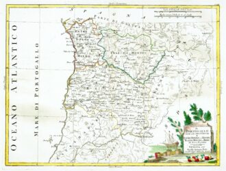
[Portugal] Il Portugallo Cioe Le Provincie di Entredouro, e Minho, Traz-Os-Montes, e Beira Di Nuova Projezione
More Info € 150,00Map of the northern half of Portugal, with attractive cartouche at lower right, showing moored ship with its cargo of barrels unloaded on the shore, next to a stone tablet on which is written the title. From Atlante Novissimo, illustrato ed accresciuto sulle osservazioni, e scoperte fatte dai più celebri e più recenti cartografi by Antonio Zatta published in Venice in 1779. Antonio Zatta was one of the leading cartographers and publishers of the time,…
- Year: 1779
- Dimension: 320 x 420 mm
- Place of publication: Venice