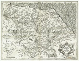
Rare copper engraving from “Nova et Accurata Italiae Hoderniae Descriptio” published in Leiden by Bonaventura e A. Elsevir in 1627. [cod.287/15]
Out of stock

Perusia
Rare copper engraving from “Nova et Accurata Italiae Hoderniae Descriptio” published in Leiden by Bonaventura e A. Elsevir in 1627. [cod.287/15]
- Year: 1627
- Dimension: 175 x 232 mm
- Place of publication: Leiden
Related products
-
![]() Out of stock
Out of stockDettagliata carta geografica della Marca di Ancona e dell’antico Ducato di Spoleto arricchita da elegante calligrafia in corsivo e da cartiglio di gusto rinascimentale con il titolo. Interessante la rappresentazione del reticolo idrografico e dell’orografia che contempla anche i rilievi minori. Tratta dall’Appendix Atlantis Majoris di G. Mercator edito ad Amsterdam nel 1606 con testo latino al verso.
- Year: 1606
- Dimension: 455 x 348 mm
- Place of publication: Amsterdam
-
![]()
Interesting regional map of Orvieto from the Atlas Major published in Amsterdam in 1664. The famous Blaeu’s firm was founded in 1596 by Willem Janzoon Blaeu (1571-1638) then continued by his two sons Cornelius (1616-1648) and Johannis (1596-1673). Their greatest cartographic achievement was the publication of the magnificent Atlas Major with 600 maps all finely engraved and embellished by elaborate cartouches, heraldic detail and especially by splendid calligraphy. The Atlas Major represents one
- Year: 1664
- Dimension: 380 x 492 mm
- Place of publication: Amsterdam
-
![]()
Fine map of Orvieto from the french edition of Atlas major published in Amsterdam in 1667. The famous Blaeu’s firm was founded in 1596 by Willem Janzoon Blaeu (1571-1638) then continued by his two sons Cornelius (1616-1648) and Johannis (1596-1673). Their greatest cartographic achievement was the publication of the magnificent Atlas Major with 600 maps all finely engraved and embellished by elaborate […]
- Year: 1667
- Dimension: 492 x 380 mm
- Place of publication: Amsterdam
-
![]()
Nice and detailed map from “Parallela geographica Italiae veteris et novae”, a very rare work by Philip Briet published in Paris in 1649 at Sebastian Cramoisy. [cod.272/15]
- Year: 1649
- Dimension: 160 x 190 mm
- Place of publication: Paris