Early map of Turkey including Cyprus from the Mercator Hondius “Atlas Minor” published in Amsterdam in 1648 at Jannsonius with german text on verso. In 1607 Jodocus Hondius published a reduced size version of Mercator’s “Atlas”, itself suitably titled “Atlas Minor”. The maps were copied from those of the great cartographer Mercator of around 1580-90 or were reductions of Hondius’ own maps of 1606. Almost 20 years later Joannes Janssonius commissioned a new set of copperplates to be engraved by Pieter Van Den Keere (Kaerius) and Abraham Goos. These maps were elegantly designed with decorative title cartouches, finely engraved and surprisingly detailed for their dimensions. Koeman “Atlantes Neerlandici” Me203.

[Turkey] Natoliae sive Asia Minor
- Year: 1648
- Dimension: 190 x 135 mm
- Place of publication: Amsterdam
€ 160,00
Related products
-
![arabia antique map]()
The fine map of the Arabian Peninsula showing Yemen, Oman, Bahrein, Qatar, Kuwait and Saudi Arabia from the first edition of Geographia di Claudio Tolomeo by Girolamo Ruscelli published in Venice in 1561 at Valgrisi. There is a really interesting Italian text on verso that describes the early history and geography of the area. A feature of this first state is that some maps haven’t the platemark at top because two maps were engraved on…
- Year: 1561
- Dimension: 180 x 240 mm
- Place of publication: Venice
-
![]()
A beautiful example of Zatta’s map from the famous Atlante Novissimo showing Korea, Manchuria, Chinese Tartary and parts of adjacent Russian Tartary, Independent Tartary, Mongolia, and Japan. Interesting very detailed depiction of the area within Korea and the unusual rendering of Hokkaido, here labeled ‘Jeso –Gasima.’ The beautiful map it also outlines the portions of the Great Wall of China. Published in Venice in 1784.
- Year: 1779
- Dimension: 315 x 405 mm
- Place of publication: Venice
-
![]()
Miniature map from “Neu aussgeffertigter kleiner Atlas” by J. Muller published in Franckfurt in 1702 at Johann Philip Andrea. Engraved with great care by G. Karsch e G. Bodeneher. Rare.
- Year: 1702
- Dimension: 70 x 80 mm
- Place of publication: Frankfurt
-
![]()
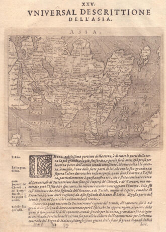
Fascinating map of Asia based on Ortelius’with the exception of the addition of a strait dividing the southern portion of the Malay Peninsula. Interesting depiction of Japan, no sign of the Korean Peninsula. Includes region south of Nova Guinea that is marked as Terrae Incognita Australis, separated from Nova Guinea by a narrow channel. Engraved by Girolamo Porro for “Geografia di Claudio Tolomeo” by Giovanni Antonio Magini published in Padua, 1621.
- Year: 1621
- Dimension: 14 x 18 cm
- Place of publication: Padova