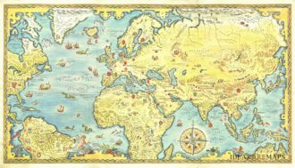
Uncommon elegant Italian map by Filippo Naymiller showing the world in two hemispheres published in Milan. Includes a second sheet of text embellished by vignettes engraved by Baldi. It provides really interesting geographical and statistical information of the continents. The map was finely engraved by Pietro Allodi. From Atlante di geografia universale: cronologico, storico, statistico e letterario. Milan, 1860 at Tipografia Pagnoni.
- Sorry, this product cannot be purchased.


Mappamondo preso sul Meridiano di Parigi
Uncommon elegant Italian map by Filippo Naymiller showing the world in two hemispheres published in Milan. Includes a second sheet of text embellished by vignettes engraved by Baldi. It provides really interesting geographical and statistical information of the continents. The map was finely engraved by Pietro Allodi. From Atlante di geografia universale: cronologico, storico, statistico e letterario. Milan, 1860 at Tipografia Pagnoni.
- Dimension: 46 x 33 cm
- Place of publication: Milan
- Year: 1860
€ 280,00
Related products
-
![]()
Globo Terrestre Delineato Sulle Ultime Osservazioni….del Cap. Cook / Globo Celeste Calcolato …. sulle Osservazioni del Sigg. Flamsteed
More Info € 9.000,00A complete set of gores (12 sheets) for a pair of globes, including calottes and printed matter for the horizon and meridian rings. The terrestrial gores show the tracks of all three of Cook’s voyages, along with his discoveries. The celestial gores, based on the observations of Flamsteed and Lacaille, are beautifully engraved and colored using the traditional, pictorial symbols for the constellations. Bound in original binding with frontispiece of Cassini’s famous work “Nuovo Atlante…
- Year: 1790
- Dimension: 320 x 490 mm
- Place of publication: Rome
-
![]()
A large very decorative Japanese world map published as sugoroku (a Japanese game which might be compared to backgammon) published as a supplement to the 1930 New Year’s Day edition of the Osaka Mainichi Shimbun newspaper. The really interesting map is drawn on a Mollweide projection instead the more commonly used Mercator projection: cartographers use the Mollweide projection when an accurate representation of area takes precedence over the accuracy of shapes. Countries are in shades…
- Dimension: 1070 x 770 mm
- Place of publication: Osaka
- Year: 1930
-
![]() Out of stock
Out of stockColorful folded pictorial map of the solar system showing the the space exploration, created shortly after the Apollo 8 mission, the first crewed spacecraft to leave low Earth orbit and the first to reach the Moon, orbit it, and return. The map is accompanied by a second separate folded sheet describing in detail (with nice design of each ship, information about carrier missiles and space suits, etc.) the most important missions from 1957 – 1968. The very interesting and decorative map shows the trajectories of both manned and unmanned spacecraft, the path of the solar system, Moon orbit, planetary orbits, relative sizes of the planets, satellites and space crafts. Includes colored reference at the lower margin. At least three editions of this map were published, this being an example of the second. The differences between the three editions revolve around the presence of Apollo missions: the first edition was published before the Apollo program began launching missions, while the second includes Apollo 8, the third edition includes the Apollo 11 mission to the Moon.
- Dimension: 84 x 111 cm
- Place of publication: Bern
- Year: 1968
-
![]() Out of stock
Out of stockRare pictorial world map designed in the style of 17th century maps by the British painter and artist Gordon Davey (1912-1992) for Pakistan Airlines in 1960. The map is an interesting and curious mix between the classic geographical representations of the golden age of explorations (the wind rose, the numerous cartouches, sea monsters, galleons) and close modernity: in each country are depicted lovely little vignettes with ancient and modern reference: see for example the Roman…
- Dimension: 45,5 x 25,5 cm
- Year: 1960