A map of the whole of Asia based on Rizzi-Zannoni finely engraved by Giuseppe Pitteri. From Atlante Novissimo by Antonio Zatta published in Venice, 1785. A dense cluster of islands, Isole Alessiane, fills the sea between Kamchatka and North America. A decorative title cartouche features an incense pot, umbrella and bird of paradise; all symbols of the exotic orient.

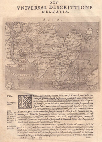
L’Asia divisa nei suoi principali Stati
A map of the whole of Asia, with decorative figured cartouche. From ‘Atlante Novissimo’.
- Year: 1779
- Dimension: 305 x 405 mm
- Place of publication: Venice
€ 280,00
Related products
-
![]()
Miniature map from “Neu aussgeffertigter kleiner Atlas” by J. Muller published in Franckfurt in 1702 at Johann Philip Andrea. Engraved with great care by G. Karsch e G. Bodeneher. Rare.
- Year: 1702
- Dimension: 70 x 80 mm
- Place of publication: Frankfurt
-
![]()
Charming map of the East Indies covering the coast of Indochina and Malaysia with the Philippines and Indonesia. The west coast of New Guinea is exaggerated and the southern coastline of Java is shown only by a dotted line. From the Mercator Hondius “Atlas Minor” published in Amsterdam in 1648 at Jannsonius with german text on verso. In 1607 Jodocus Hondius published a reduced size version of Mercator’s “Atlas”, itself suitably titled “Atlas Minor”. The maps were copied from those of the great
- Year: 1648
- Dimension: 195 x 145 mm
- Place of publication: Amsterdam
-
![]()
Fascinating map of Asia based on Ortelius’with the exception of the addition of a strait dividing the southern portion of the Malay Peninsula. Interesting depiction of Japan, no sign of the Korean Peninsula. Includes region south of Nova Guinea that is marked as Terrae Incognita Australis, separated from Nova Guinea by a narrow channel. Engraved by Girolamo Porro for “Geografia di Claudio Tolomeo” by Giovanni Antonio Magini published in Padua, 1621.
- Year: 1621
- Dimension: 14 x 18 cm
- Place of publication: Padova
-
![]()
Magnificent Coronelli’s map of the Indian Peninsula, from Guzarat to the Ganges. The map shows India below the Tropic of Cancer, with an insets of Ceylon and Trincomalee. It shows in very nice detail settlements, administrative division, larger towns, place names, rivers and canals. One of the most important and impressive large format 17th Century maps of the area. From the monumental Corso Geografico Universale published in Venice in 1690. Vincenzo Maria Coronelli is widely recognized as one of…
- Year: 1690
- Dimension: 454 x 605 mm
- Place of publication: Venice