Interesting map of North America engraved on copper by Glot. From the scarce “Atlas Portatif, contenant la Gographie Universelle Ancienne et Moderne” by Eustache Herisson published in Paris in 1809 at Desray.
- Sorry, this product cannot be purchased.
Out of stock

L’Amerique Septentrionale
Interesting map of North America engraved on copper by Glot. From the scarce “Atlas Portatif, contenant la Gographie Universelle Ancienne et Moderne” by Eustache Herisson published in Paris in 1809 at Desray.
- Year: 1809
- Dimension: 218 x 180 mm
- Place of publication: Paris
Related products
-
![]()
Paraguay o Prov. De Rio De La Plata cum regionibus adiacentibus Tucuman et Sta. Cruz De la Sierra
More Info € 140,00Early pocket map of the Rio de La Plata region in Uruguay showing also part of Argentina from the Mercator Hondius “Atlas Minor” published in Amsterdam in 1648 at Jannsonius with german text on verso. In 1607 Jodocus Hondius published a reduced size version of Mercator’s “Atlas”, itself suitably titled “Atlas Minor”. The maps were copied from those of the great cartographer Mercator of around 1580-90 or were reductions of Hondius’ own maps of 1606. Almost 20 years later Joannes Janssonius commi
- Year: 1648
- Dimension: 193 x 145 mm
- Place of publication: Amsterdam
-
![]() Out of stock
Out of stockA map of South America containing Tierra-Firma, Guayana, New Granada, Amazonia, Brasil, Peru, Paraguay, Chaco, Tucuman, Chili…
More InfoA magnificent wall map in 4 sheets joined of South America published by Robert Sayer (1725 – 1794) and John Bennett (active: 1770-1784) in London in 1775. Depicts the continent in full with inset of the Falkland’s Islands at top right. Heavily detailed map, with countless place names, a large scenic & elaborate cartouche at lower right. The cartouche displays a skirted native in headdress, sack of gold coins, fruits. vegetation, a dog, raft, birds, and a distant river scene with small huts. A descriptive panel at the left margin detailing the “Division of South America with a Summary Account of its’ Trade”. Some minor creases where the folds crossing. Overall in good condition.
- Year: 1775
- Dimension: 990 x 1180 mm
- Place of publication: London
-
![]()
An exceptional 1932 bird’s eye view map of the city of Quebec, Canada by Samuel Herbert Maw. The densely filled map displays parks, buildings, named streets and historic notations embellished by numerous coats of arms and a large compass rose. Born in England, Maw was an architect, delineator, etcher, cartographer and designer. After winning the Sloane Medallion from the Royal Institute of British Architects in 1905 and showing at the Royal Academy in London in…
- Year: 1932
- Dimension: 850 x 650 mm
- Place of publication: Toronto
-
![]()
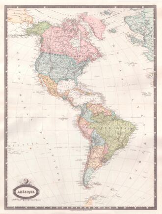
Interesting map of America with high detail and beautiful decorative colouring. The Panama Canal has not yet been built. Colombia is “Nouvelle Grenade” and Alaska is “Amerique Russe”. Much of the Amazon is labeled as “Selvas”, or tropical rainforests, and “Région Inconnue”. From Atlas Spheroidal et Universel de Geographie by M.F.A. Garnier published in Paris at Veuve Jules Renouard in 1862. This atlas is exceptional for its “spheroidal” maps of the globe, showing the various…
- Year: 1862
- Dimension: 680 x 510 mm
- Place of publication: Paris