Northern Eastern Spain, showing the Pyrenees and south to Valencia with decorative title cartouche. From ‘Atlante Novissimo’.Very good condition with nice and decorative original colours.
- Sorry, this product cannot be purchased.
Out of stock

Related products
-
![]()
Carte itineraire physique politique et routiere de l’Espagne et du Portugal: indiquant les trois grandes Regions geographiques les ancines et les nouvelles Divisions
More Info € 600,00This extremely uncommon carte-a-figures map from the 19th century features the Iberian Peninsula and is surrounded with defly engraved figures and representations of places of note in Spain and Portugal. The vignettes flanking the map include Alhambra, Malaga, The Giralda Bell Tower of the Cathedral of Seville, Burgos Cathedral, Tower of Orangers in Seville, St. Nicholas’s Tower in Cordova, the Carmel Convent, Madrid, Lisbon and El Prado in addition to others. The figures below the map include a bull fighter and typical attire for residents of various parts of Spain and Portugal. The map is filled with details of roads, towns and cities, as well as topography and was made as a folding map to assist travelers in the region.
- Dimension: 53,5 x 73 cm
- Place of publication: Paris
- Year: 1840
-
![]()
Detailed map of the eastern coastline of Spain, centred on Valencia, Murcia and the Balearic Islands of Ibiza, Minorca and Majorca. From Atlante Novissimo, illustrato ed accresciuto sulle osservazioni, e scoperte fatte dai più celebri e più recenti cartografi by Antonio Zatta published in Venice in 1779. Antonio Zatta was one of the leading cartographers and publishers of the time, and his Atlante Novissimo was one of the most beautifully produced of 18th-century atlases. He…
- Year: 1779
- Dimension: 300 x 400 mm
- Place of publication: Venice
-
![]()
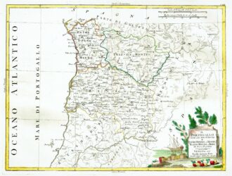
[Portugal] Il Portugallo Cioe Le Provincie di Entredouro, e Minho, Traz-Os-Montes, e Beira Di Nuova Projezione
More Info € 150,00Map of the northern half of Portugal, with attractive cartouche at lower right, showing moored ship with its cargo of barrels unloaded on the shore, next to a stone tablet on which is written the title. From Atlante Novissimo, illustrato ed accresciuto sulle osservazioni, e scoperte fatte dai più celebri e più recenti cartografi by Antonio Zatta published in Venice in 1779. Antonio Zatta was one of the leading cartographers and publishers of the time,…
- Year: 1779
- Dimension: 320 x 420 mm
- Place of publication: Venice
-
![]()
A very fine map from the first edition of “Geographia di Claudio Tolomeo” by Girolamo Ruscelli published in Venice in 1561 at Valgrisi. There is a really interesting Italian text on verso that describes the early history and geography of the area. A feature of this first state is that some maps haven’t the platemark at the top because two maps were engraved on the same plate and the resulting sheet halved. Ruscelli’s Atlas is…
- Year: 1561
- Dimension: 180 x 240 mm
- Place of publication: Venice