Excellent map of Hudson Bay, Baffin Bay, part of Greenland, Labrador and Northern Canada. From “Atlante Novissimo, illustrato ed accresciuto sulle osservazioni, e scoperte fatte dai piu’ celebri e piu’ recenti cartografi” by Antonio Zatta published in Venice in 1779. Very good condition with nice and decorative original colours. [cod.1092/15]
- Sorry, this product cannot be purchased.

La Baia d’ Hudson Terra di Labrador e Groenlandia
Excellent map of Hudson Bay, Baffin Bay, part of Greenland, Labrador and Northern Canada. From “Atlante Novissimo, illustrato ed accresciuto sulle osservazioni, e scoperte fatte dai piu’ celebri e piu’ recenti cartografi” by Antonio Zatta published in Venice in 1779. Very good condition with nice and decorative original colours. [cod.1092/15]
- Year: 1779
- Dimension: 300 x 405 mm
- Place of publication: Venice
€ 300,00
Related products
-
![]()
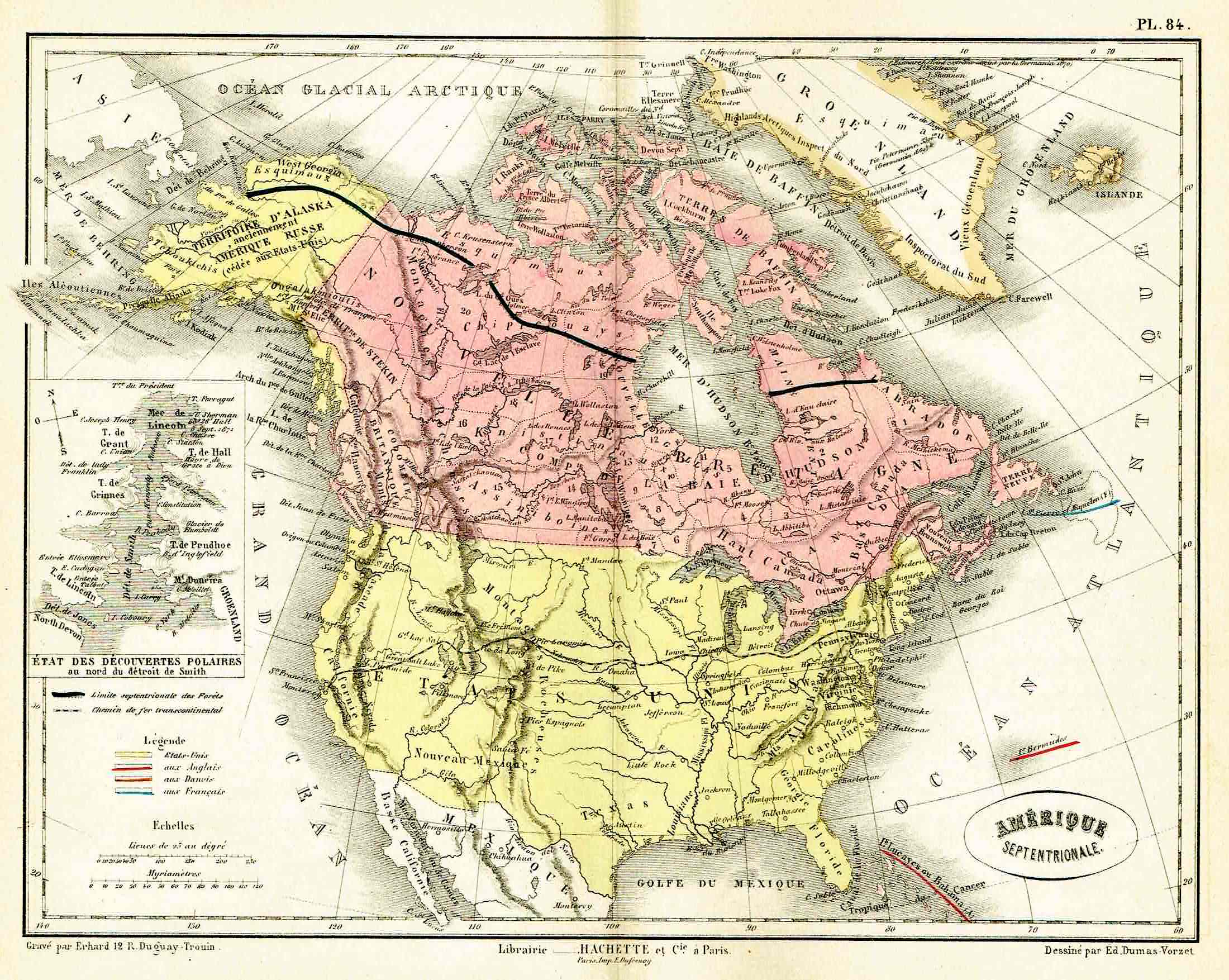
Lovely map by Eduard Dumas-Vorzet showing in nice details north America and Canada. At left inset the new polar discoveries on the Smith Sounds. From the famous Atlas Universel d’Histoire et de Geographie by Marie Nicolas Bouillet published in Paris in 1877.
- Year: 1877
- Place of publication: Paris
- Dimension: 260 x 200 mm
-
![]()
Lovely pictorial map of the United States featuring information about the varied backgrounds of the citizens and the industries in different parts of the country. The very decorative promotional map issued for the Brussels Universal Exhibition of 1958 shown on America as a multi-national, multi-cultural nation. The map is covered with pictorial images of historical sites and Americans working and playing. Labels on each state show the principal national origins of the residents, for example, Danish, Dutch and German in South Dakota. Across the top are eight figures in stereotypical native clothing (kilt, sombrero, wooden shoes). Puerto Rico, Hawaii, and Alaska are shown as territories. At Bottom left the author’s signature. This map was issued as a folded map and it retains its folds.
- Dimension: 49 x 69 cm
- Year: 1958
-
![]() Out of stock
Out of stockPictorial map of the United States featuring portraits of iconic American Jazz musicians like: Paul Desmond, Dave Brubeck, Jimmy Giuffre, Lambert, Hendricks & Ross, Gerry Mulligan, Bessie Smith, Coleman Hawkins, Stan Kenton, Lester Young, Woody Herman, John Coltrane, Bix Beiderbecke, Louis Armstrong, Count Basie, Charlie Parker, Art Tatum, Bennv Goodman, Dizzy Gillespie, Oscar Peterson, Billie Holidav, Lennie Tristano, Stan Getz, Ornette Coleman, Jerry Roll Morton, Eric Dolphy, Duke Ellington, Ella Fitzgerald, Charles Mingus, Gil Evans.…
- Dimension: 100 x 69 cm
- Place of publication: Ferrara
- Year: 1984
-
![antica mappa della baia di hudson]()
Rare map of the Northwest Passage, Northern Canada, part of Alaska (America Russa) and Greenland showing the known islands of the Northwest Passage, including several partially known coastlines. From the rarest and most elegant cartographic work by Francesco Celestino Marmocchi, the Corso di Geografia Commerciale published in Genoa in 1858.
- Dimension: 25 x 38 cm
- Place of publication: Genoa
- Year: 1858