Handsome map of Spain from the Mercator Hondius “Atlas Minor” published in Amsterdam in 1648 at Jannsonius with german text on verso. In 1607 Jodocus Hondius published a reduced-size version of Mercator’s “Atlas”, itself suitably titled “Atlas Minor”. The maps were copied from those of the great cartographer Mercator of around 1580-90 or were reductions of Hondius’ own maps of 1606. Almost 20 years later Joannes Janssonius commissioned a new set of copper plates to be engraved by Pieter Van Den Keere (Kaerius) and Abraham Goos. These maps were elegantly designed with decorative title cartouches, finely engraved and surprisingly detailed for their dimensions. Koeman “Atlantes Neerlandici” Me203.

Related products
-
![]()
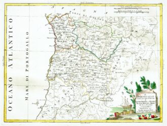
[Portugal] Il Portugallo Cioe Le Provincie di Entredouro, e Minho, Traz-Os-Montes, e Beira Di Nuova Projezione
More Info € 150,00Map of the northern half of Portugal, with attractive cartouche at lower right, showing moored ship with its cargo of barrels unloaded on the shore, next to a stone tablet on which is written the title. From Atlante Novissimo, illustrato ed accresciuto sulle osservazioni, e scoperte fatte dai più celebri e più recenti cartografi by Antonio Zatta published in Venice in 1779. Antonio Zatta was one of the leading cartographers and publishers of the time,…
- Year: 1779
- Dimension: 320 x 420 mm
- Place of publication: Venice
-
![]()
Fine map of Portugal oriented with west at the top (and north incorrectly pointing south on the compass rose) from Corso Geografico Universale by Vincenzo Coronelli published in Venice, 1690. A decorative title cartouche appears in bottom center embellished with military flags and canon. The scales cartouche and the arms of Portugal and Algarve are supported by mermen in the Atlantic and four smaller crests represent the adjacent regions of Spain. At bottom right the…
- Year: 1690
- Dimension: 594 x 444 mm
- Place of publication: Venice
-
![]()
Detailed map of the eastern coastline of Spain, centred on Valencia, Murcia and the Balearic Islands of Ibiza, Minorca and Majorca. From Atlante Novissimo, illustrato ed accresciuto sulle osservazioni, e scoperte fatte dai più celebri e più recenti cartografi by Antonio Zatta published in Venice in 1779. Antonio Zatta was one of the leading cartographers and publishers of the time, and his Atlante Novissimo was one of the most beautifully produced of 18th-century atlases. He…
- Year: 1779
- Dimension: 300 x 400 mm
- Place of publication: Venice
-
![]()
Uncommon and elegant Italian map by Filippo Naymiller showing Spain and Portugal published in Milan. Includes a second sheet of text embellished by vignettes of Madrid and Lisbona engraved by Baldi. It provides really interesting geographical and statistical information of the Countries. The map was finely engraved by Pietro Allodi. From Atlante di geografia universale: cronologico, storico, statistico e letterario Milan, 1860 at Litografia Pagnoni.
- Dimension: 32 x 42 cm
- Place of publication: Milan
- Year: 1860