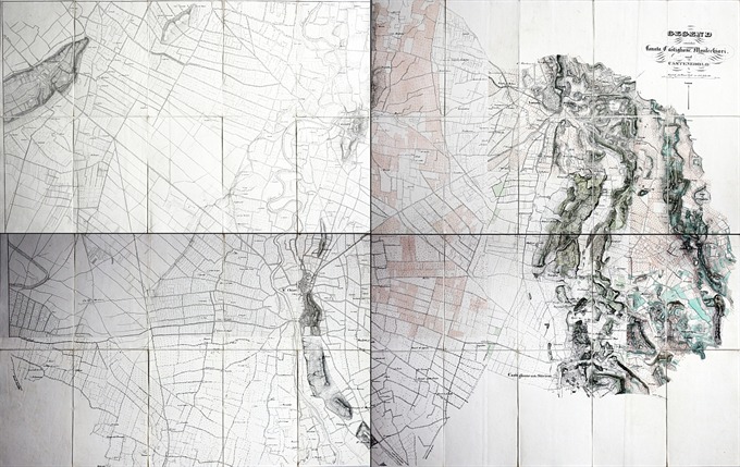
A rare large map of Lonato, Castiglione delle Stiviere, Montichiari and Castenedolo dissected and backed on linen. Published in Wien in 1820 ca.
- Sorry, this product cannot be purchased.
Gegend zwischen Lonato, Castiglione, Montichiari und Castenedolo
A rare large map of Lonato, Castiglione delle Stiviere, Montichiari and Castenedolo dissected and backed on linen. Published in Wien in 1820 ca.
- Author: Ufficio Topografico Militare Austriaco
- Year: 1820
- Dimension: 1450 x 900 mm
- Place of publication: Vienna
€ 1.400,00
Related products
-
[Brescia] Veduta di Brescia da Porta San Nazaro – Terra Antiqua, potens armis atque ubere glebe dedicata a Luigi Arici
More InfoLa più importante, ambita e rara veduta generale della città di Brescia
- Author: Domenico Carboni
- Year: 1764
- Dimension: 1360 x 605 mm
- Place of publication: Brescia
-
Nice lithograph by Mller-Wegmann showing the Swiss Italian Alps (M. Sissone; P. Bracone; Cima di Cantone; Cima di Castella; Castello; M. di Zocca; Pizzi Gemelli etc.). Published in Bern in 1879.
- Author: HARDING James Duffield
- Year: 1836
- Dimension: 270 x 385 mm
- Place of publication: London
-
prezzo a richiesta] Questa rarissima carta geografica del Bresciano appartiene alla cosiddetta Scuola Cartografica di Colonia che per circa mezzo secolo fu il centro pi importante nella produzione geografica dovuta principalmente ai cartografi ed artisti fiamminghi ed olandesi che fuggivano dalle persecuzioni religiose. Gli esponenti maggiori furono Mattheus Quad, Giovanni Botero, Johannes Metellus e il fondatore … [cod.996/15]
- Author: RASCICOTTI Donato
- Year: 1599
- Dimension: 500 x 375 mm
- Place of publication: Venice
-
Out of stock
Interesting map of Brescia and Crema from the Atlas Major published in Amsterdam in 166. The famous Blaeu’s firm was founded in 1596 by Willem Janzoon Blaeu (1571-1638) then continued by his two sons Cornelius (1616-1648) and Johannis (1596-1673). Their greatest cartographic achievement was the publication of the magnificent Atlas Major with 600 maps all finely engraved and embellished by elaborate cartouches, heraldic detail and especially by splendid callig
- Author: BLAEU Johannis
- Year: 1667
- Dimension: 380 x 500 mm
- Place of publication: Amsterdam


