Very detailed map of Mexico with the Caribbean includes an inset of Central America and Panama. Interesting Depiction of Arizona and New Mexico. From Atlas Spheroidal et Universel de Geographie by M.F.A. Garnier published in Paris at Veuve Jules Renouard in 1862. This atlas is exceptional for its “spheroidal” maps of the globe, showing the various continents and poles, shaded to give the effect of a sphere floating in space. The remaining maps are also very well executed and colored. This is the only atlas that Garnier produced, according to Phillips. (836)
- Sorry, this product cannot be purchased.

Etats-Unis du Mexique, Amerique Centrale, comprenant les Republiques de Guatemala….
- Year: 1862
- Dimension: 340 x 500 mm
- Place of publication: Paris
€ 180,00
Related products
-
![]()
Lovely postcard showing the meeting at Panama between the Pacific and Atlantic oceans as a kiss. Published by Curt Otto Teich in 1935 for Sucesion de Maduro a hats and parfumes shop in Panama. Curt Teich who immigrated to the United States from Lobenstein, Germany, in 1896, founded the Curt Teich Company of Chicago, which operated from 1898 to 1978 as the world’s largest printer of view and advertising postcards.
- Dimension: 90 x 140 mm
- Place of publication: Chicago
- Year: 1935
-
![]()
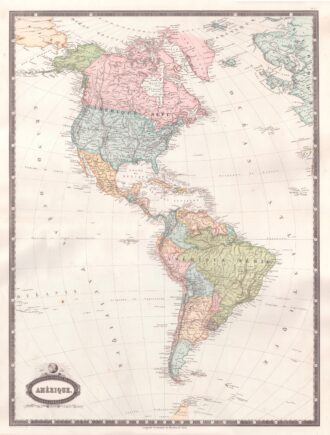
Interesting map of America with high detail and beautiful decorative colouring. The Panama Canal has not yet been built. Colombia is “Nouvelle Grenade” and Alaska is “Amerique Russe”. Much of the Amazon is labeled as “Selvas”, or tropical rainforests, and “Région Inconnue”. From Atlas Spheroidal et Universel de Geographie by M.F.A. Garnier published in Paris at Veuve Jules Renouard in 1862. This atlas is exceptional for its “spheroidal” maps of the globe, showing the various…
- Year: 1862
- Dimension: 680 x 510 mm
- Place of publication: Paris
-
![]() Out of stock
Out of stockA finely engraved copper plate map that covers Chili and most of Argentina. Good detail of the region around Buenos Ayres and the Rio de la Plata. Santiago here is named Rioja. A large inset details Tierra del Fuego and the Strait of Magellan. From “Atlante Novissimo, illustrato ed accresciuto sulle osservazioni, e scoperte fatte dai piu’ celebri e piu’ recenti cartografi” by Antonio Zatta published in Venice in 1779. [cod.1020/15]
- Year: 1779
- Dimension: 410 x 315 mm
- Place of publication: Venice
-
![]()
Detailed map of Peru, extending from just North of Guayqauil to just South of the Tropic of Capricorn, showing the western Amazon, Andes, Lake Titicaca, and the many regions and Territories. From “Atlante Novissimo, illustrato ed accresciuto sulle osservazioni, e scoperte fatte dai piu’ celebri e piu’ recenti cartografi” by Antonio Zatta published in Venice in 1779-85. Antonio Zatta was a prominent Italian editor, cartographer, and publisher. Little is known about his life beyond his…
- Year: 1779
- Dimension: 407 x 310 mm
- Place of publication: Venice