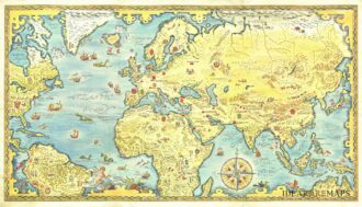
Porcacchi’s world map is a finely executed reduction of Camocio’s Wall Map of 1567, one of the last wall maps to follow Gastaldi’s wall map of 1546. The map shows a narrow strait between America and Asia. California is shown as a peninsula. Limited information on the east coast, although Florida is named. No obvious entry for either the Hudson or St. Lawrence Rivers The Amazon is depicted, but flowing north-south. Massive southern continent shown, along with a north polar land mass. From “L’Isole piu Famose del Mondo” by T. Porcacchi and engraved by Girolamo Porro. Published in Venice in 1604. Inset in a page with italian text. [cod.1215/15]
- Sorry, this product cannot be purchased.
Out of stock

Descrittione del mappamondo
Porcacchi’s world map is a finely executed reduction of Camocio’s Wall Map of 1567, one of the last wall maps to follow Gastaldi’s wall map of 1546. The map shows a narrow strait between America and Asia. California is shown as a peninsula. Limited information on the east coast, although Florida is named. No obvious entry for either the Hudson or St. Lawrence Rivers The Amazon is depicted, but flowing north-south. [cod.1215/15]
- Year: 1604
- Dimension: 106 x 146 mm
- Place of publication: Venice
Related products
-
![]() Out of stock
Out of stockColor pictorial map of the world showing travel Lufthansa’s routes and connections with Lufthansa plane flying over map of the world. Map representing landmarks, major cities, and people. Includes compass rose decorated with Lufthansa logo.
- Dimension: 46,5 x 72 cm
- Place of publication: Berlin-Schonefeld
- Year: 1962
-
![]() Out of stock
Out of stockFirst edition of the decorative double hemisphere pictorial map prepared by Luc-Marie Bayle for TAI Transport Aeriens Intercontinentaux with two decorative compass rose oriented with the north to the upper margin. The hemispheres are surrounded by fun images of various explorers in divers modes of transport a hot air balloon, early and later forms of aeroplanes, rowing boats, sailing ships, galleons, whales and fish. TAI routes are shown in red. The Transport Aeriens Intercontinentaux company began as a charter airline in June 1946 in association with the Messageries Maritime Shipping Company.
- Dimension: 51 x 73 cm
- Place of publication: Paris
- Year: 1948
-
![]() Out of stock
Out of stockRare pictorial world map designed in the style of 17th century maps by the British painter and artist Gordon Davey (1912-1992) for Pakistan Airlines in 1960. The map is an interesting and curious mix between the classic geographical representations of the golden age of explorations (the wind rose, the numerous cartouches, sea monsters, galleons) and close modernity: in each country are depicted lovely little vignettes with ancient and modern reference: see for example the Roman…
- Dimension: 45,5 x 25,5 cm
- Year: 1960
-
![]()
Uncommon elegant Italian map by Filippo Naymiller showing the world in two hemispheres published in Milan. Includes a second sheet of text embellished by vignettes engraved by Baldi. It provides really interesting geographical and statistical information of the continents. The map was finely engraved by Pietro Allodi. From Atlante di geografia universale: cronologico, storico, statistico e letterario. Milan, 1860 at Tipografia Pagnoni.
- Dimension: 46 x 33 cm
- Place of publication: Milan
- Year: 1860