An exceptional 1932 bird’s eye view map of the city of Quebec, Canada by Samuel Herbert Maw. The densely filled map displays parks, buildings, named streets and historic notations embellished by numerous coats of arms and a large compass rose. Born in England, Maw was an architect, delineator, etcher, cartographer and designer. After winning the Sloane Medallion from the Royal Institute of British Architects in 1905 and showing at the Royal Academy in London in 1909, Maw moved to Canada where he spent the remainder of his successful career designing buildings, squares and landmarks. He is best known for his perspective drawings, such as this one, heralded as “a masterpiece of Canadian cartography, a bird’s-eye view of Quebec City, begun in 1926 and completed in 1932, in which he accurately rendered every single building in the Old Town and surrounding area, complete with a hand-drawn cartouche and historical notes on the significance of the buildings shown.

[Canada] City of Quebec with Historical Notes
- Year: 1932
- Dimension: 850 x 650 mm
- Place of publication: Toronto
€ 350,00
Related products
-
![]()
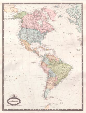
Interesting map of America with high detail and beautiful decorative colouring. The Panama Canal has not yet been built. Colombia is “Nouvelle Grenade” and Alaska is “Amerique Russe”. Much of the Amazon is labeled as “Selvas”, or tropical rainforests, and “Région Inconnue”. From Atlas Spheroidal et Universel de Geographie by M.F.A. Garnier published in Paris at Veuve Jules Renouard in 1862. This atlas is exceptional for its “spheroidal” maps of the globe, showing the various…
- Year: 1862
- Dimension: 680 x 510 mm
- Place of publication: Paris
-
![]()
Amerique ou Noveau Continent dresse sur le nouvelle relations decouvertes et observations par J.B. Nolin
More Info € 700,00A fascinating engraved map dated third years after the French revolution showing all of North and South America published in Paris by Basset, based upon work of Johann Baptist Nolin. The map includes a large inset map showing the “New Discoveries” in the Northwest part of America, most notably the depiction of prospective routes from Hudson’s Bay and Baffin’s Bay to the Pacific Ocean, based upon information provided by Joseph Nicolas De L’Isle, reporting on…
- Year: 1795
- Dimension: 470 x 680 mm
- Place of publication: Paris
-
![]()
An attractive miniature map of Chile and Central Argentina by Thomas Starling from popular Victorian atlas “The Royal Cabinet Atlas, And Universal Compendium Of All Places In The Known World” published by Bull and Churton in London in 1833. The map is accompanied by a page of text giving the latitude and longitude of the major towns.
- Year: 1833
- Dimension: 90 x 145 mm
- Place of publication: London
-
![]()
A finely copper engraved map by G. Pitteri showing the modern-day nations of Uruguay, Paraguay, and parts of adjacent Brazil and Argentina.. Rich detail is offered throughout, naming mountains, rivers, national boundaries, cities, regions, and indigenous tribes. Identifies Asuncion, Buenos Aires, Rio de Janeiro, and numerous other important South American cities. From Atlante Novissimo, illustrato ed accresciuto sulle osservazioni, e scoperte fatte dai più celebri e più recenti cartografi by Antonio Zatta published in Venice in…
- Year: 1779
- Dimension: 400 x 320 mm
- Place of publication: Venice