A large and detailed chart of Jamaica by Bellin showing its main towns and geographical features and its relation to Cuba and Santo Domingo. Published in Paris in 1753.
- Sorry, this product cannot be purchased.
Out of stock

Carte Reduite de L’Isle de La Jamaique…
- Year: 1753
- Dimension: 910 x 570 mm
- Place of publication: Paris
Related products
-
![]()
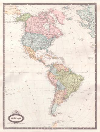
Interesting map of America with high detail and beautiful decorative colouring. The Panama Canal has not yet been built. Colombia is “Nouvelle Grenade” and Alaska is “Amerique Russe”. Much of the Amazon is labeled as “Selvas”, or tropical rainforests, and “Région Inconnue”. From Atlas Spheroidal et Universel de Geographie by M.F.A. Garnier published in Paris at Veuve Jules Renouard in 1862. This atlas is exceptional for its “spheroidal” maps of the globe, showing the various…
- Year: 1862
- Dimension: 680 x 510 mm
- Place of publication: Paris
-
![]()
An exceptional 1932 bird’s eye view map of the city of Quebec, Canada by Samuel Herbert Maw. The densely filled map displays parks, buildings, named streets and historic notations embellished by numerous coats of arms and a large compass rose. Born in England, Maw was an architect, delineator, etcher, cartographer and designer. After winning the Sloane Medallion from the Royal Institute of British Architects in 1905 and showing at the Royal Academy in London in…
- Year: 1932
- Dimension: 850 x 650 mm
- Place of publication: Toronto
-
![]() Out of stock
Out of stockLovely copper engraved maps of Cuba above Hispaniola, with smaller insets of Havana, Jamaica, Puerto Rico and Margarita. Usual printer?s defect for this edition at right where border did not print due the damage of the copper. Otherwise very good. From the Mercator Hondius “Atlas Minor” published in Amsterdam in 1648 at Jannsonius with german text on verso. In 1607 Jodocus Hondius published a reduced size version of Mercator’s “Atlas”, itself suitably titled “Atlas Minor”. The maps were copied
- Year: 1648
- Dimension: 180 x 143 mm
- Place of publication: Amsterdam
-
![]()
An attractive miniature map of South America by Thomas Starling from popular Victorian atlas “The Royal Cabinet Atlas, And Universal Compendium Of All Places In The Known World” published by Bull and Churton in London in 1833. The map is accompanied by a page of text giving the latitude and longitude of the major towns.
- Year: 1833
- Dimension: 90 x 145 mm
- Place of publication: London