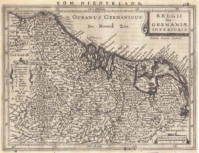
Fine map engraved by Petrus Kaerius, this map is filled with mountains, cities and villages. The map is oriented with north at right and is decorated with strapwork title, distance scale and key cartouches. From the Mercator Hondius “Atlas Minor” published in Amsterdam in 1648 at Jannsonius with german text on verso. In 1607 Jodocus Hondius published a reduced size version of Mercator’s “Atlas”, itself suitably titled “Atlas Minor”. The maps were copied from those of the great cartographer Mercator of around 1580-90 or were reductions of Hondius’ own maps of 1606. Almost 20 years later Joannes Janssonius commissioned a new set of copperplates to be engraved by Pieter Van Den Keere (Kaerius) and Abraham Goos. These maps were elegantly designed with decorative title cartouches, finely engraved and surprisingly detailed for their dimensions. Koeman “Atlantes Neerlandici” Me203.
[Netherlands – Belgium] Belgii sive Germaniae Inferioris
- Author: MERCATOR Gerard - HONDIUS Henricus
- Year: 1648
- Dimension: 205 x 160 mm
- Place of publication: Amsterdam
€ 180,00
Related products
-
Very detailed map of Liege area from Coronelli’s Corso Geografico Universale published in Venice in 1690. Vincenzo Maria Coronelli is widely recognised as one of Italy’s most famous and greatest cartographers. He received an ecclesiastical education at the convent of the Minor Conventuals and also studied theology in Rome. However, his interests in geography and cartography were awoken early in his ecclesiastical career and never suppressed. He made very famous globes (including an impressive very…
- Author: CORONELLI Vincenzo Maria
- Year: 1690
- Dimension: 450 x 606 mm
- Place of publication: Venice
-
A particularly attractive pictorial map of Belgium by anonymous author published in 1930 circa. This map is covered with vignettes describing major towns and landmarks along the roads. Includes decorative cartouche, compass rose and inset lovely views of Audenarde, Bruges and Malines. Uncommon.
- Author: Anon.
- Dimension: 24 x 34 cm
- Year: 1930
-
Very detailed map of Namur region in central Belgium. Includes several coats of arms and decorative cartouche with the dedication to Solari. From Coronelli’s Corso Geografico Universale published in Venice in 1690. Vincenzo Maria Coronelli is widely recognised as one of Italy’s most famous and greatest cartographers. He received an ecclesiastical education at the convent of the Minor Conventuals and also studied theology in Rome. However, his interests in geography and cartography were awoken early…
- Author: CORONELLI Vincenzo Maria
- Year: 1690
- Dimension: 450 x 605 mm
- Place of publication: Venice
-
A very nice aquatint view by Gabriel Lory showing Mont Blanc glacier at the foot of a hill with a stream flowing from it and some bare rock in the foreground; two figures on the left of the mouth of the cave and three in the right hand foreground. Published in Paris at Osterwald in 1820.
- Author: Gabriel Lory
- Dimension: 25 x 28 cm
- Place of publication: Paris
- Year: 1820


