Very decorative prospect view of Athens showing the major buildings and places of interest. From Corso Geografico Universale by Coronelli published in Venice in 1690. Vincenzo Maria Coronelli is widely recognised as one of Italy’s most famous and greatest cartographers. He received an ecclesiastical education at the convent of the Minor Conventuals and also studied theology in Rome. However, his interests in geography and cartography were awoken early in his ecclesiastical career and never suppressed. He made very famous globes (including an impressive very large-scale pair for Louis XIV) and some of the most interesting and decorative atlases of all 17th century like Atlante Veneto, Isolario, Corso Geografico Universale, Libro dei Globi and also some pocket books about towns and islands. These important works are all finely engraved in his unique style with a high quantity of toponymic and historical information. In 1680 Coronelli also founded the oldest surviving geographical society “The Argonauts Academy”.

Antica e Moderna Citta d’Atene dedicata dal P. Coronelli
- Year: 1690
- Dimension: 610 x 458 mm
- Place of publication: Venice
Related products
-
![]() Out of stock
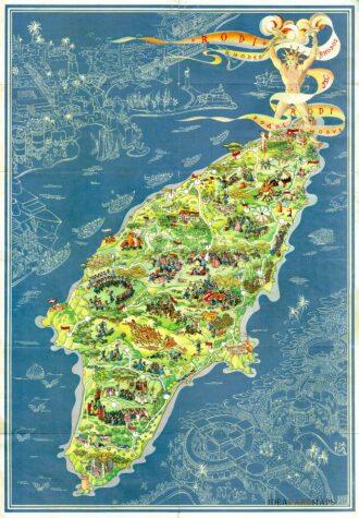
Out of stockPictorial map of Rhodes, the island of the sun or rose island in Greece by Egon Huber. Published by Ente Nazionale del Turismo Italiano in Milan at Pizzi & Pizzi, 1935. Shows roads, woods, forts, lighthouses, people in various recreational activities, etc. Also shows buildings, landmarks, ships and boats in white over blue sea. On verso 14 photos of Rodi as well as rich information about Rodi island. The list of the photos: “La citta…
- Dimension: 46,5 x 67 cm
- Place of publication: Milan
- Year: 1935
-
![pictorial map cyprus]()
A beautiful pictorial map of Cyprus by the Greek artist Spyros Vassiliou and published in Athens in February 1965 by the Government Press and Information Office. The map depicts famous mythological places and describes historical events through refined vignettes. On the lower right, a cartouche in classical style shows the population density divided by Turks and Greeks, while a second insert on the upper left highlights Cyprus’s position in the world. At the bottom, a…
- Dimension: 69 x 53 cm
- Place of publication: Athens
- Year: 1965
-
![]()
Nautical chart from J. Roux’s “Carte de la Mer Mediterranee en douze feuilles? published in Marsile in 1764. Sanderson, The Sea Chart, p. 91. Rare. [cod.1193/15]
- Year: 1764
- Dimension: 800 x 545 mm
- Place of publication: Marsiglia
-
![]()
Detailed map of Crete published in 1866 by Dietrich Reimer and based on the representation of the island drawn by the English hydrographer, geologist and vice-admiral Thomas Abel Brimage Spratt (1881-1888). The interesting map also features an inset with the valley of Mylopotamos, a locality in the northern part of the island, in the prefecture of Rethymnon. It will be reprinted in 1897 (Cf. Bibliothèque nationale de France, GED-2736 ) with the addition in plate…
- Dimension: 25 x 54 cm
- Place of publication: Berlin
- Year: 1866