This attractive map shows all of the continent in Zatta’s beautiful style that exemplifies his fine engraving. The map extends to include part of Central America and south to show all of Patagonia and the Straits of Magellan. The title cartouche rests in the lower left corner and features plants and fruit. The map names and delineates each political region, and is filled with place names and good detail of rivers and mountains. From Atlante Novissimo, illustrato ed accresciuto sulle osservazioni, e scoperte fatte dai più celebri e più recenti cartografi by Antonio Zatta published in Venice in 1779. [cod.1169]
- Sorry, this product cannot be purchased.

America Meridionale divisa ne suoi principali Stati
- Year: 1779
- Dimension: 300 x 400 mm
- Place of publication: Venice
€ 280,00
Related products
-
![]()
Etats-Unis du Mexique, Amerique Centrale, comprenant les Republiques de Guatemala….
More Info € 180,00Very detailed map of Mexico with the Caribbean includes an inset of Central America and Panama. Interesting Depiction of Arizona and New Mexico. From Atlas Spheroidal et Universel de Geographie by M.F.A. Garnier published in Paris at Veuve Jules Renouard in 1862. This atlas is exceptional for its “spheroidal” maps of the globe, showing the various continents and poles, shaded to give the effect of a sphere floating in space. The remaining maps are also…
- Year: 1862
- Dimension: 340 x 500 mm
- Place of publication: Paris
-
![]()
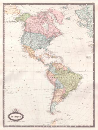
Interesting map of America with high detail and beautiful decorative colouring. The Panama Canal has not yet been built. Colombia is “Nouvelle Grenade” and Alaska is “Amerique Russe”. Much of the Amazon is labeled as “Selvas”, or tropical rainforests, and “Région Inconnue”. From Atlas Spheroidal et Universel de Geographie by M.F.A. Garnier published in Paris at Veuve Jules Renouard in 1862. This atlas is exceptional for its “spheroidal” maps of the globe, showing the various…
- Year: 1862
- Dimension: 680 x 510 mm
- Place of publication: Paris
-
![]() Out of stock
Out of stockInteresting map of Newfoundland and Cap Breton Island, along with neighbouring Islands, including St. Pierre Michelon. From Atlante Novissimo, illustrato ed accresciuto sulle osservazioni, e scoperte fatte dai piu’ celebri e piu’ recenti cartografi by Antonio Zatta published in Venice in 1779. [cod.1170]
- Year: 1779
- Dimension: 420 x 315 mm
- Place of publication: Venice
-
![]()
An exceptional 1932 bird’s eye view map of the city of Quebec, Canada by Samuel Herbert Maw. The densely filled map displays parks, buildings, named streets and historic notations embellished by numerous coats of arms and a large compass rose. Born in England, Maw was an architect, delineator, etcher, cartographer and designer. After winning the Sloane Medallion from the Royal Institute of British Architects in 1905 and showing at the Royal Academy in London in…
- Year: 1932
- Dimension: 850 x 650 mm
- Place of publication: Toronto