Milan
Showing 1–12 of 58 results
-
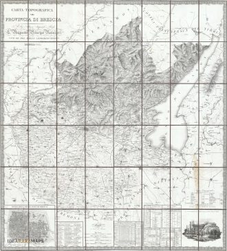
![antica mappa carta geografica provincia di Brescia]() Out of stock
Out of stockMagnificent map of Brescia dedicated to Giovanni Michele Ranieri published in Milan, 1826
- Dimension: 110 x 123 cm
- Place of publication: Milan
- Year: 1826
-
![europe as queen]() Out of stock
Out of stockAn uncommon map of Europe in the shape of a Queen after the same image published by Munster in 1588. Europa as Queen is the map-like depiction of the European continent as a Queen. Made popular in the 1500s, the map shows Europe standing upright, with the Iberian Peninsula forming her crowned head, and Bohemia her heart. During the late 16th Century, a few map makers created these really interesting map images, wherein countries and continents were given human or animal forms. This example was published in Cosmorama Pittorico, Milan 1850. The description on verso explain, curiously, that the Singolar Carta d’Europa (strange map of Europe) shows surely King Charles V.
- Dimension: 10,5 x 17 cm
- Place of publication: Milan
- Year: 1850
-
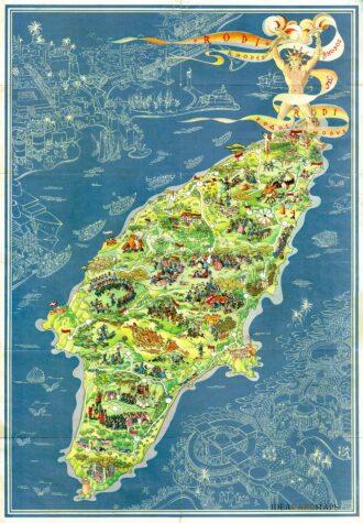
![]() Out of stock
Out of stockPictorial map of Rhodes, the island of the sun or rose island in Greece by Egon Huber. Published by Ente Nazionale del Turismo Italiano in Milan at Pizzi & Pizzi, 1935. Shows roads, woods, forts, lighthouses, people in various recreational activities, etc. Also shows buildings, landmarks, ships and boats in white over blue sea. On verso 14 photos of Rodi as well as rich information about Rodi island. The list of the photos: “La citta…
- Dimension: 46,5 x 67 cm
- Place of publication: Milan
- Year: 1935
-
![]() Out of stock
Out of stockA detailed town plan of Milan, showing the fortified walls, city gates, inner ring, important public buildings, squares, and much more. At right a key to the most important hotels, churches and theatres including useful information for the travelers.
- Dimension: 32 x 37 cm
- Place of publication: Milan
- Year: 1879
-
![]()
Elegant Italian map by Filippo Naymiller showing The Netherlands published in Milan. Includes a second sheet of text embellished by vignettes of Amsterdam and Brussels engraved by Baldi. It provides really interesting geographical and statistical information of the Countries. The map was finely engraved by Pietro Allodi. From Atlante di geografia universale: cronologico, storico, statistico e letterario Milan, 1860 at Litografia Pagnoni.
- Dimension: 32 x 42 cm
- Place of publication: Milan
- Year: 1860
-
![]()
Rare copper engraving with original (uncommon) color. From “Piante delle citt , piazze e castelli fortificati…dello Stato di Milano” by G.B. Sesti published in Milan in 1707. Sold with a second leaf with the description of the town. [cod.337/15]
- :
- Dimension: 195 x 150 mm
- Place of publication: Milan
-
![]() Out of stock
Out of stockDelizioso atlantino storico dedicato ai fanciulli che mostra, con l’ausilio di curiose piccole carte geografiche traforate, la storia delle suddivisioni territoriali dal 1848 al 1929. Edizione speciale a cura della Società Unica di Torino. Edito a Milano nel 1930 da Giovanni De Agostini.
- Dimension: 23 x 15,5 cm
- Place of publication: Milan
- Year: 1930
-
![]() Out of stock
Out of stockPlan of the town from “Piante delle citt capoluoghi delle Provincie del Regno Lombardo Veneto che mostrano la situazione dei principali Stabilimenti Civili e Militari in esse esistenti”published in Milan in 1838. Rare original colours. [cod.354/15]
- Year: 1838
- Dimension: 220 x 185 mm
- Place of publication: Milan
-
![antica veduta di brescia]()
An important view of Brescia drawn by Gaetano Gariboldi published in Milan by Antonio Vallardi in 1850. The view, one of the rarest and most sought-after depiction of the city, is centered on Piazza Loggia and shows in fine detail on the left the Duomo and on the right the Loggia. In the background the city in a lively and refined original colouring.
- Dimension: 90 x 25 cm
- Place of publication: Milan
- Year: 1850
-
![]() Out of stock
Out of stockCarta amministrativa del Regno d’Italia co’ suoi stabilimenti politici, militari, civili … per ordine del ministro della guerra e marina nell’anno 1813
More InfoGrande carta murale del Regno d’Italia concepita dal Deposito della Guerra di Milano e realizzata da Gaudenzio Bordiga. In alto a sinistra il riquadro con il titolo contiene anche la “ricapitolazione” dei dati statistico-amministrativi del Regno e a seguire una legenda di 22 voci con i segni convenzionali, ancora sotto una nota in cui si indicano le fonti della carta tra le quali si precisa che la Valtellina e tutta la parte alla destra del…
- Dimension: 129 x 109 cm
- Place of publication: Milan
- Year: 1813
-
![]()
Fascinating map, showing the routes of the Barbarians throughout Europe and the Mediterranean finely engraved by Pietro Allodi after a drawn by Filippo Naymiller. From Atlante di geografia universale: cronologico, storico, statistico e letterario. Milan, 1860 at Tipografia Pagnoni.
- Year: 1860
- Place of publication: Milan
- Dimension: 43 x 33 cm
-
![carta lombardo veneto]() Out of stock
Out of stockLarge map of the Kingdom of Lombardy-Venetia drawn by Gaetano Monticelli here in the final edition of 1866, which is characterised by the beautiful and detailed representation of Istria. Interesting and precise is the orography designed with a particular stroke to give a sense of three-dimensionality to the reliefs. The important river system of the territory and the rich toponymy with the indication of many urban centres, even minor ones, are highlighted. First and second class communication routes are indicated, as well as those that can be travelled, with the relevant post stations The map is completed in the bottom left-hand corner by the table with the ‘Prospetto Statistico delle Provincie del Regno Lombardo Veneto’ (Statistical Prospectus of the Provinces of the Lombardy-Veneto Kingdom). Published in Milan in 1866 at Artaria.
- Dimension: 52 x 89,5 cm
- Place of publication: Milan
- Year: 1866