World
Showing 49–60 of 186 results
- Sorry, this product cannot be purchased.
-
![]()
Striking pictorial planisphere showing an elongated terrestrial globe with Air France routes in white, surrounded by a richly decorated border of landscapes. The map shows routes east to Japan and west to the Americas. A significant expansion of the airline network. Numerous vignettes illustrate special landmarks, people and animals. Lucien Boucher is a commercial poster artist and illustrator born in Chartres in 1889 and died in 1971. Graduated from the Ecole de céramiques de Sèvres,…
- Dimension: 95 x 58 cm
- Place of publication: Paris
- Year: 1959
-
![]()
The uncommon small version of the world map poster designed by Lucien Boucher in 1948 for Air France. The map shows routes east to Japan and west to the Americas. A significant expansion of the airline network. Numerous vignettes illustrate special landmarks, people and animals. Lucien Boucher is a commercial poster artist and illustrator born in Chartres in 1889 and died in 1971. Graduated from the Ecole de céramiques de Sèvres, he began his career…
- Dimension: 33 x 58 cm
- Place of publication: Paris
- Year: 1948
-
![]()
The smal version of one of Boucher’s most remarkable promotional maps designed for Air France.
- Dimension: 35 x 58 cm
- Place of publication: Paris
- Year: 1952
-
![]() Out of stock
Out of stockDivertente planisfero disegnato da Luigi Roveri e Giuseppe Orliani per la compagnia aerea Alitalia e pubblicato a Roma nel 1975 presso l’editore Daniele Cerretti. Destinata all’infanzia questa carta geografica-pittorica ben si fonde con lo stile grafico degli autori che avendo collaborato per la rivista Miao, nota per le sue storie senza testo, riesce a descrive in maniera sintetica ma riuscita i costumi e le peculiarità delle varie aree del mondo. Luigi Roveri è stato un…
- Dimension: 43 x 65 cm
- Place of publication: Rome
- Year: 1976
-
![]()
Fine map by Giovanni Antonio Magini engrave day Girolamo Porro based on Giovanni Lorenzo d’Anania’s 1582 map of the Americas and further based on the geography of Ortelius. Most notable is the characteristic bulge to the west coast of South America and the huge Southern Continent that attaches to Nova Guinea. Anian and Quivira appear on North America’s bulbous western coast. From Geografia di Claudio Tolomeo published in Padua in 1621 at Galignani.
- Year: 1621
- Dimension: 14 x 18 cm
- Place of publication: Padova
-
![]()
This attractive map shows all of the continent in Zatta’s beautiful style that exemplifies his fine engraving. The map extends to include part of Central America and south to show all of Patagonia and the Straits of Magellan. The title cartouche rests in the lower left corner and features plants and fruit. The map names and delineates each political region, and is filled with place names and good detail of rivers and mountains. From Atlante…
- Year: 1779
- Dimension: 300 x 400 mm
- Place of publication: Venice
-
![]()
Rare map of Alaska (America Russa) and the contiguous parts of Canada and the US extending to the Upper Missouri River and the Fraser River. The map is one of the earliest printed maps to focus on the region which would become Alaska. From the rarest and most elegant cartographic work by Francesco Celestino Marmocchi, the Corso di Geografia Commerciale published in Genoa in 1858.
- Dimension: 27 x 34 cm
- Place of publication: Genoa
- Year: 1858
-
![]()
Interesting map of America with high detail and beautiful decorative colouring. The Panama Canal has not yet been built. Colombia is “Nouvelle Grenade” and Alaska is “Amerique Russe”. Much of the Amazon is labeled as “Selvas”, or tropical rainforests, and “Région Inconnue”. From Atlas Spheroidal et Universel de Geographie by M.F.A. Garnier published in Paris at Veuve Jules Renouard in 1862. This atlas is exceptional for its “spheroidal” maps of the globe, showing the various…
- Year: 1862
- Dimension: 680 x 510 mm
- Place of publication: Paris
-
![]()
Amerique ou Noveau Continent dresse sur le nouvelle relations decouvertes et observations par J.B. Nolin
More Info € 700,00A fascinating engraved map dated third years after the French revolution showing all of North and South America published in Paris by Basset, based upon work of Johann Baptist Nolin. The map includes a large inset map showing the “New Discoveries” in the Northwest part of America, most notably the depiction of prospective routes from Hudson’s Bay and Baffin’s Bay to the Pacific Ocean, based upon information provided by Joseph Nicolas De L’Isle, reporting on…
- Year: 1795
- Dimension: 470 x 680 mm
- Place of publication: Paris
-
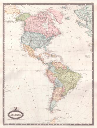
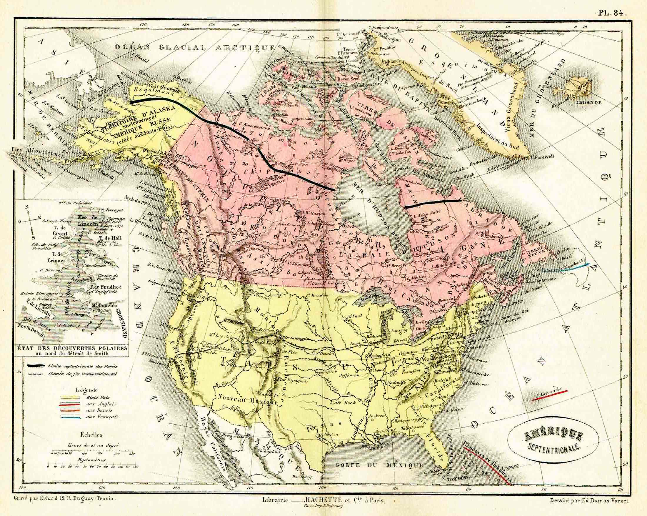
![]()
Lovely map by Eduard Dumas-Vorzet showing in nice details north America and Canada. At left inset the new polar discoveries on the Smith Sounds. From the famous Atlas Universel d’Histoire et de Geographie by Marie Nicolas Bouillet published in Paris in 1877.
- Year: 1877
- Place of publication: Paris
- Dimension: 260 x 200 mm
-
![]()
Miniature map from “Neu aussgeffertigter kleiner Atlas” by J. Muller published in Franckfurt in 1702 at Johann Philip Andrea. Engraved with great care by G. Karsch e G. Bodeneher. Rare.
- Year: 1702
- Dimension: 70 x 80 mm
- Place of publication: Frankfurt
-
![]()
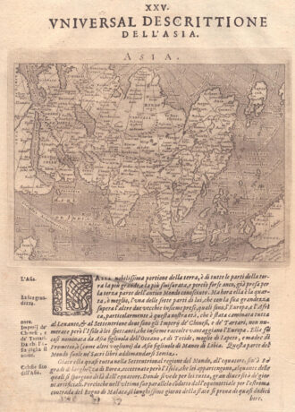
Fascinating map of Asia based on Ortelius’with the exception of the addition of a strait dividing the southern portion of the Malay Peninsula. Interesting depiction of Japan, no sign of the Korean Peninsula. Includes region south of Nova Guinea that is marked as Terrae Incognita Australis, separated from Nova Guinea by a narrow channel. Engraved by Girolamo Porro for “Geografia di Claudio Tolomeo” by Giovanni Antonio Magini published in Padua, 1621.
- Year: 1621
- Dimension: 14 x 18 cm
- Place of publication: Padova