A large and detailed chart of Jamaica by Bellin showing its main towns and geographical features and its relation to Cuba and Santo Domingo. Published in Paris in 1753.
Out of stock

Carte Reduite de L’Isle de La Jamaique…
- Year: 1753
- Dimension: 910 x 570 mm
- Place of publication: Paris
Related products
-
![]()
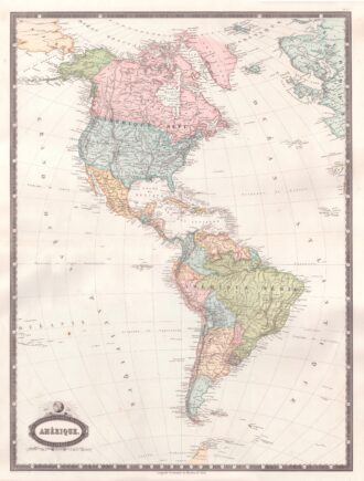
Interesting map of America with high detail and beautiful decorative colouring. The Panama Canal has not yet been built. Colombia is “Nouvelle Grenade” and Alaska is “Amerique Russe”. Much of the Amazon is labeled as “Selvas”, or tropical rainforests, and “Région Inconnue”. From Atlas Spheroidal et Universel de Geographie by M.F.A. Garnier published in Paris at Veuve Jules Renouard in 1862. This atlas is exceptional for its “spheroidal” maps of the globe, showing the various…
- Year: 1862
- Dimension: 680 x 510 mm
- Place of publication: Paris
-
![]()
Lovely engraved map based on the cartography by C. Franz Radefeld (1788-1874) showing the Arkansas, Mississipi, Louisiana, Alabama and Florida Panhandle. Inset of New Oreleans suurndings. From the “Meyer’s Neuester Zeitungs Atlas” published by Bibliographischen Instituts in Hildburghausen in 1849-52. The innovation of this work is that almost all maps had small inserts showing richly detailed maps of major cities and their surrunding areas: so not only could travellers carry the atlas with them
- Year: 1849
- Dimension: 270 x 200 mm
- Place of publication: Hildburghausen
-
![]()
Fine example of Coronelli’s map of the Caribbean. Centered on Hispaniola the map shows from the Southern tip of Florida and the Canal di Bahama to the Yucatan, to the Easternmost Antilles and Trinidad. Includes also the Caymans, Virgin Islands and smaller islands of the coast of Mexico. The cartouche also contains a dedication to Sebastiano Bernardi. Vincenzo Maria Coronelli is widely recognised as one of Italy?s most famous and greatest cartographers. He received an…
- Year: 1690
- Dimension: 257 x 430 mm
- Place of publication: Venice
-
![]()
An attractive miniature map of South America by Thomas Starling from popular Victorian atlas “The Royal Cabinet Atlas, And Universal Compendium Of All Places In The Known World” published by Bull and Churton in London in 1833. The map is accompanied by a page of text giving the latitude and longitude of the major towns.
- Year: 1833
- Dimension: 90 x 145 mm
- Place of publication: London